 By Elina
 Burrard Bridge Vancouver is more than a transportation route between downtown and Kitsilano. Its Art Deco architecture, elevated views across False Creek, and convenient pedestrian and cycling connections make it an interesting destination for walking, photography, and urban sightseeing.
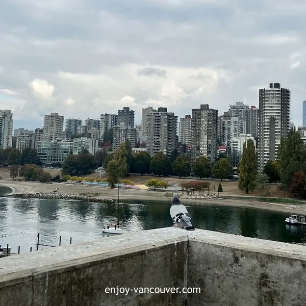
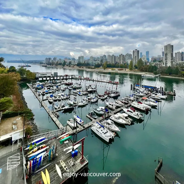
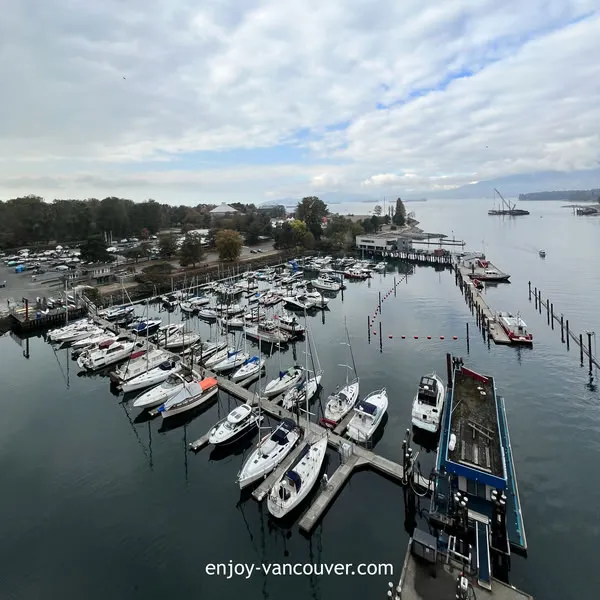
A walk across the bridge provides changing views of downtown Vancouver, Granville Island, English Bay, the North Shore mountains, surrounding marinas, and the waterfront neighbourhoods on both sides of False Creek.
The crossing itself does not take long, but it can easily become part of a longer route through Sunset Beach, the West End, Vanier Park, Kitsilano, Granville Island, or the False Creek Seawall.
This Burrard Bridge walking and photo guide covers the location, walking route, best viewpoints, photography conditions, cycling access, nearby attractions, accessibility, and practical visitor tips.
Burrard Bridge Vancouver: Quick Visitor Information
- Location: Between downtown Vancouver and Kitsilano
- Admission: Free
- Best for: Walking, cycling, architecture, waterfront views, and photography
- Bridge crossing time: Approximately 15–25 minutes without long stops
- Recommended visit: 45–90 minutes with photography stops
- Best conditions: Clear mornings, late afternoons, and sunset
📍 Location
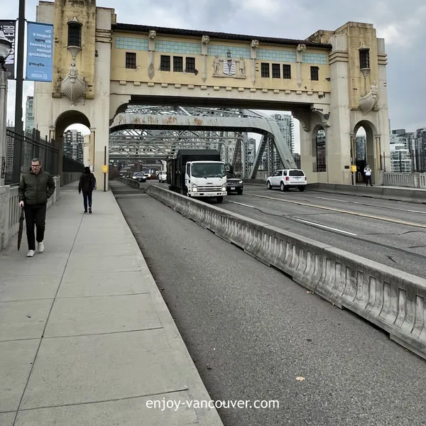
Burrard Bridge crosses False Creek and connects Burrard Street in downtown Vancouver with the Kitsilano and Fairview areas south of the water.
The northern entrance is close to the West End, Sunset Beach, Beach Avenue, and downtown Vancouver. The southern entrance provides access toward Kitsilano, Vanier Park, West 4th Avenue, and the southern False Creek waterfront.
Visitors can approach the bridge from several central Vancouver locations, including:
- Downtown Vancouver
- The West End
- Sunset Beach
- Yaletown
- The False Creek Seawall
- Kitsilano
- Vanier Park
- Granville Island
The bridge is open to pedestrians, cyclists, transit vehicles, and general traffic. Temporary restrictions may occasionally affect access because of maintenance, nearby construction, traffic management, or special events.
✨ Why Walk Across Burrard Bridge?
Walking across Burrard Bridge combines architecture, city views, waterfront scenery, and convenient access between two different parts of Vancouver.
The view changes as you move across the bridge. Downtown towers rise behind the northern entrance, while the southern side opens toward Kitsilano, Vanier Park, Granville Island, and the wider waters leading toward English Bay.
During the crossing, visitors may see:
- Downtown Vancouver’s skyline
- Boats moving through False Creek
- Granville Island and nearby marinas
- Kitsilano and Vanier Park
- The North Shore mountains in clear weather
- Sunset colours toward English Bay
- The bridge’s towers and geometric architectural details
The walk is especially useful for visitors who enjoy urban photography but do not want to travel far from central Vancouver. It also works well as a free activity that can be added to a longer downtown or waterfront itinerary.
🏛️ History and Architecture
Burrard Bridge opened in 1932 and improved transportation between downtown Vancouver and the neighbourhoods south of False Creek.
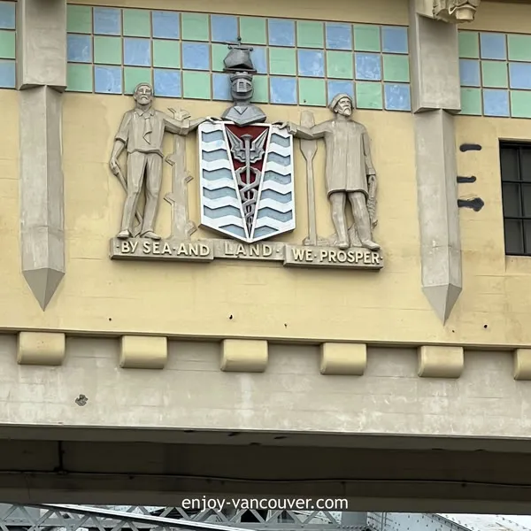
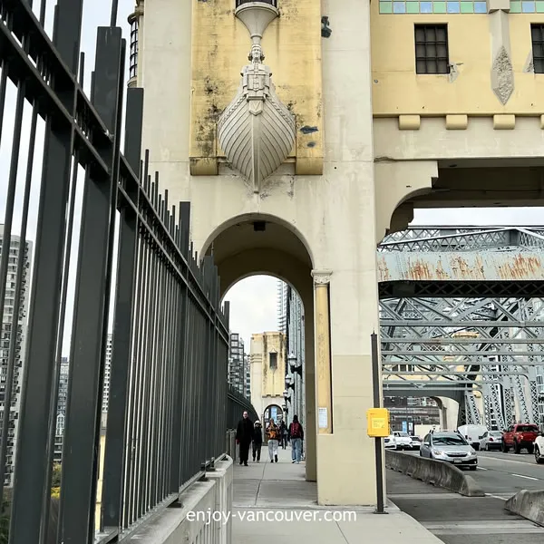
The bridge was designed as both functional infrastructure and a civic landmark. Its towers, concrete details, strong vertical lines, and geometric decorative elements reflect the Art Deco style of the early 1930s.
Its design creates a gateway between False Creek and English Bay. From the water, the towers mark the entrance to False Creek. From the roadway and pedestrian paths, they create a recognizable transition between downtown Vancouver and Kitsilano.
The bridge entrances also include memorial braziers created to honour those who served during the First World War. These architectural elements contribute to the bridge’s historical and civic significance.
Visitors interested in architecture should look beyond the main span and pay attention to the towers, lighting, entrance structures, decorative concrete, and the relationship between the bridge and the surrounding waterfront.
🚶 Burrard Bridge Walking Route
The bridge can be crossed in either direction. The best starting point depends on where you are staying and which nearby attractions you plan to visit.
Downtown Vancouver to Kitsilano
Starting from downtown is convenient for visitors staying in the city centre, West End, Yaletown, or Coal Harbour.
Approach Burrard Street from Pacific Street or Beach Avenue and follow the pedestrian route onto the bridge. As you walk south, the view gradually opens toward False Creek, Vanier Park, Kitsilano, and the waterfront beyond.
After crossing the bridge, you can continue toward:
- Vanier Park
- Kitsilano Beach
- West 4th Avenue
- Granville Island
- The Seaside Greenway
- Jericho Beach on a longer route
Kitsilano to Downtown Vancouver
Walking north provides a stronger approach toward Vancouver’s downtown skyline.
This direction can be especially attractive during the morning or late afternoon, when light reflects from the downtown buildings and the surface of False Creek.
After reaching the downtown side, visitors can continue toward:
- Sunset Beach
- English Bay
- Davie Village
- The West End
- Yaletown
- The north False Creek Seawall
How Long Does the Walk Take?
A direct crossing normally takes approximately 15–25 minutes, depending on walking speed, pedestrian traffic, and the number of photography stops.
Visitors who stop frequently for views may spend 30–45 minutes on the bridge. A longer route that includes nearby parks, beaches, or waterfront paths may take two to four hours.
📸 Best Burrard Bridge Photo Spots
From the Bridge Walkway
The pedestrian route provides elevated views across False Creek and the surrounding neighbourhoods.
Good photography subjects include:
- Downtown Vancouver towers
- Boats and marinas below the bridge
- Granville Island
- The North Shore mountains
- Sunset over the western horizon
- The bridge towers framing the pedestrian path
Remain within the pedestrian area and avoid placing bags, tripods, or other equipment where they could obstruct people walking or using mobility aids.
From Sunset Beach
The waterfront near Sunset Beach provides a useful angle toward the bridge and its northern entrance.
This location works well for:
- Wide photographs of the bridge
- Waterfront foregrounds
- Evening light
- Bridge and skyline combinations
- People walking along the waterfront
From Vanier Park
Vanier Park offers broad views across False Creek toward Burrard Bridge and downtown Vancouver.
The open waterfront provides space for wider compositions. The bridge can be framed with grass, pathways, trees, boats, or downtown buildings.
From the False Creek Seawall
Sections of the False Creek Seawall provide side views of the bridge. Moving east or west changes the relationship between the bridge, skyline, water, marinas, and surrounding residential buildings.
Near the Bridge Approaches
Areas near the bridge entrances can reveal structural lines that are less visible from the bridge deck. These angles are useful for architectural photography showing the bridge supports, towers, underside, and scale.
Remain in publicly accessible areas and do not enter construction zones, private property, service areas, or restricted waterfront spaces.
🌅 Best Time for Photography
Morning
Morning can provide clearer views, softer light, and fewer pedestrians. It is a practical time for photographing the bridge’s architecture and views toward downtown Vancouver.
Late Afternoon
Late-afternoon light often produces warmer tones on the bridge and surrounding buildings. This is also a good time to combine the walk with Sunset Beach or Vanier Park.
Sunset
Sunset can be the most atmospheric time to visit. Western views may include warm colours, silhouettes, reflected light, and boats moving across False Creek.
The bridge can become busier on pleasant summer evenings. Keep photography equipment close and avoid blocking the pedestrian route.
Blue Hour and Evening
Shortly after sunset, the bridge lighting and downtown skyline become more visible. Remain on designated paths, watch for cyclists and pedestrians, and secure valuable equipment.
Cloudy Weather
Overcast conditions can work well for architectural photography. Softer shadows make it easier to capture concrete details, towers, and geometric features without strong contrast.
🚴 Cycling Across Burrard Bridge
Burrard Bridge is an important connection in Vancouver’s protected cycling network.
Protected bicycle lanes separate cyclists from motor vehicles and pedestrian areas. The cycling lanes operate in specific directions, so riders should follow all arrows, pavement markings, and traffic signals.
Cycling connections from the bridge include:
- Downtown Vancouver cycling routes
- Beach Avenue
- The False Creek Seawall
- The Seaside Greenway
- Kitsilano
- Jericho Beach
- Spanish Banks on a longer route
The Seaside Greenway connects the Burrard Bridge area with Vancouver’s western waterfront. Visitors planning a longer ride should check the current City of Vancouver cycling map and temporary construction notices before starting.
Basic cycling reminders include:
- Follow lane arrows and traffic signals.
- Use the correct direction of travel.
- Slow down near bridge entrances and intersections.
- Watch for pedestrians at crossing points.
- Use bicycle lights when visibility is limited.
- Check for temporary closures or detours.
🚆 How to Get to Burrard Bridge
From Downtown Vancouver
Walk south along Burrard Street toward Pacific Street and the northern bridge entrance. Visitors coming from the West End can also approach through Beach Avenue or the nearby waterfront paths.
From Yaletown
Follow the north False Creek waterfront west toward Burrard Bridge. This route provides marina, residential, and waterfront views before reaching the bridge entrance.
From Kitsilano
Approach from Burrard Street, Cornwall Avenue, West 1st Avenue, Vanier Park, or nearby walking and cycling routes.
By Public Transit
Bus routes operate along Burrard Street and through nearby downtown and Kitsilano neighbourhoods. Routes and stop locations may change because of construction, events, or transit-service adjustments.
Check the current TransLink Trip Planner before travelling rather than relying on an older timetable.
By Bicycle
Protected cycling routes connect Burrard Bridge with downtown Vancouver, the West End, False Creek, Kitsilano, and the Seaside Greenway.
By Car
Driving is possible, but parking directly beside the bridge is limited. Visitors planning to walk and take photographs may find it easier to park farther away and approach from Sunset Beach, Vanier Park, Kitsilano, or downtown Vancouver.
♿ Accessibility
The bridge crossing uses paved pedestrian routes, but visitors should expect gradual slopes at both entrances and exposure to wind, traffic noise, and changing weather.
The route may be manageable for many wheelchairs, mobility devices, and strollers. Individual comfort will depend on slope tolerance, pedestrian congestion, construction conditions, and the selected approach.
Visitors with mobility considerations should:
- Check for temporary closures or detours before travelling.
- Choose a quieter time of day.
- Allow extra time for the incline.
- Use accessible transit or drop-off locations near the bridge entrance.
- Avoid carrying unnecessary equipment.
- Review nearby washroom locations in advance.
Construction near the bridge or surrounding developments may occasionally affect access. Follow posted signs and current City of Vancouver notices.
☀️ Best Time to Visit
Spring
Spring offers mild walking conditions, longer daylight, and fresh waterfront scenery. Rain and changing temperatures are still possible, so bring a light waterproof layer.
Summer
Summer provides comfortable conditions for walking, photography, cycling, and combining the bridge with nearby parks or beaches.
Sunny evenings may be busy, particularly around sunset and during major waterfront events.
Autumn
Autumn can provide cooler temperatures, changing light, and fewer visitors. Wind and rain become more common as the season progresses.
Winter
Winter offers quieter conditions and dramatic coastal skies, but the bridge can feel cold and exposed. Wear waterproof clothing and avoid crossing during severe wind or unsafe weather.
For comfortable walking and photography, choose a clear weekday morning or late afternoon.
🎒 What to Bring
- Comfortable walking shoes
- A light or waterproof jacket
- Water
- Sunscreen during summer
- A charged phone
- A camera or phone camera
- A secure camera strap
- A portable charger
- Sunglasses for bright waterfront conditions
- A small bag that does not obstruct the walkway
Wind can be stronger on the bridge than on nearby streets. Bring an extra layer even when conditions feel warm at ground level.
💡 Insider Tips
- Walk from Kitsilano toward downtown for a stronger skyline view.
- Walk from downtown toward Kitsilano for wider views across False Creek.
- Visit in the late afternoon and continue toward Sunset Beach for sunset.
- Use Vanier Park for wider photographs of the complete bridge.
- Keep cameras and bags out of the pedestrian route.
- Do not stand in bicycle lanes to take photographs.
- Check current traffic and construction notices before visiting.
- Use a wrist or neck strap when photographing near the railing.
- Bring an extra layer because the bridge can be windy.
- Combine the bridge with a longer waterfront walk.
- Do not enter construction or restricted areas near the bridge entrances.
- Download a map before starting a longer False Creek route.
🗺️ Suggested Walking Routes
Short Burrard Bridge Walk
Route: Downtown entrance → cross Burrard Bridge → return by the opposite pedestrian route or retrace your path
Time needed: Approximately 45–60 minutes with photo stops
Best for: Architecture, city views, and visitors with limited time
Sunset Beach to Vanier Park
Route: Sunset Beach → Burrard Bridge → Vanier Park
Time needed: Approximately 60–90 minutes
Best for: Waterfront scenery, bridge photography, and sunset views
Yaletown to Kitsilano
Route: Yaletown waterfront → north False Creek Seawall → Burrard Bridge → Kitsilano
Time needed: Approximately two to three hours, depending on stops
Best for: A longer urban waterfront walk
Burrard Bridge and Granville Island
Route: Downtown Vancouver → Burrard Bridge → Vanier Park → Granville Island
Time needed: Approximately two to three hours, excluding time spent at Granville Island
Best for: First-time visitors, photography, food, and waterfront sightseeing
ℹ️ Visitor Information
⏱️ Time Needed
Allow 45–90 minutes for a relaxed bridge crossing with photography stops. Allow two to four hours when adding Sunset Beach, Vanier Park, Yaletown, Kitsilano, or Granville Island.
Cost
Walking and cycling across Burrard Bridge are free.
Possible additional costs include:
- Public transit fares
- Bicycle rental
- Parking
- Food and drinks
- Admission to nearby attractions
Washrooms
There are no public washrooms directly on the bridge. Use facilities in nearby parks, commercial areas, or attractions before starting the crossing.
Best For
- Urban walking
- Architecture
- Photography
- Cycling
- Waterfront views
- Sunset walks
- First-time Vancouver visitors
- Free outdoor activities
🔗 Nearby Vancouver Guides
Continue planning your Vancouver visit with these related Enjoy Vancouver guides:
- Best Things to Do in Vancouver
- David Lam Park and Yaletown Waterfront Guide
- Vancouver Fireworks Guide
- Gastown Vancouver Walking Guide
- Science World Vancouver Visitor Guide
- Ambleside Park West Vancouver Guide
- Capilano Suspension Bridge Guide
Frequently Asked Questions
Can you walk across Burrard Bridge?
Yes. Burrard Bridge has designated pedestrian routes connecting downtown Vancouver with the Kitsilano side of False Creek.
How long does it take to walk across Burrard Bridge?
A direct crossing normally takes approximately 15–25 minutes. Visitors stopping for photographs may need 30–45 minutes.
Is it free to walk across Burrard Bridge?
Yes. There is no admission charge for walking or cycling across Burrard Bridge.
What can you see from Burrard Bridge?
Views may include False Creek, downtown Vancouver, Granville Island, nearby marinas, Kitsilano, boats, English Bay, and the North Shore mountains.
Is Burrard Bridge good for photography?
Yes. The bridge provides opportunities for city, waterfront, architectural, mountain, boat, and sunset photography. Sunset Beach and Vanier Park offer additional viewpoints.
Can you cycle across Burrard Bridge?
Yes. Protected bicycle lanes cross the bridge and connect with downtown Vancouver and Kitsilano cycling routes. Cyclists must follow marked directions and traffic signals.
What is the best time to visit Burrard Bridge?
Clear mornings are suitable for quieter walks, while late afternoon and sunset provide warmer light and more atmospheric views across False Creek.
Is Burrard Bridge accessible?
The pedestrian routes are paved, but the bridge entrances include gradual slopes. Accessibility can also be affected by congestion, weather, construction, and temporary detours.
When was Burrard Bridge built?
Burrard Bridge opened in 1932 and is recognized for its Art Deco architecture and civic gateway design.
✅ Final Thoughts
Burrard Bridge Vancouver is a practical transportation route, a recognizable heritage landmark, and one of the city’s easiest free locations for waterfront and skyline photography.
The walk is short enough to fit into a downtown itinerary but visually varied enough to deserve time for several stops. Views of False Creek, Granville Island, downtown towers, boats, mountains, and sunset make it especially useful for photographers and visitors exploring Vancouver on foot.
For a more complete experience, combine the crossing with Sunset Beach, Vanier Park, Kitsilano, Yaletown, or the False Creek Seawall.
Before visiting, check current route conditions, remain within the pedestrian area, avoid blocking cyclists, and bring an extra layer for changing waterfront weather.